Namibia — Africa’s Last Wilderness
The least densely populated country on earth outside Mongolia. A vast, primordial world of 300m sand dunes, ancient desert-adapted wildlife, shipwreck-strewn Atlantic coastline, and skies so dark they’re internationally recognised for stargazing. Namibia is Africa stripped back to its geological bones.
World’s Oldest Desert
The Namib is 80 million years old — its dunes have been shifting and resettling since before dinosaurs walked the earth. The result is a landscape of staggering, almost hallucinatory beauty.
Sossusvlei & Dead Vlei
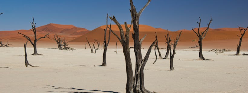
📍 Hardap Region · Namib-Naukluft National ParkA white clay pan ringed by 300–400m dunes in which 900-year-old camel thorn tree skeletons stand blackened against orange sand — Dead Vlei was cut off from the river when dunes shifted. The trees died but the extreme aridity preserved them perfectly. Climbing Dune 45 at dawn, watching the valley transform from silver to fire below you, is the defining Namibia experience.
🔴 Peak May–Oct · 🟢 Good Jan, Nov–Dec
Getting There
Fly Windhoek–Sesriem or drive 5hrs. Enter Sesriem Gate at first light — it opens 1hr before sunrise. Drive to Dune 45 (45 min from gate), climb at dawn, then drive to the 2WD carpark for the 1km walk to Sossusvlei and Dead Vlei. The walk from Sossusvlei to Dead Vlei takes about 20 minutes through soft sand.
Practical Tips

NamibRand Nature Reserve
📍 Hardap Region · Adjacent to Namib-NaukluftA 172,000-hectare private reserve bordering Sossusvlei — one of only a handful of International Dark Sky Reserves on earth. The Milky Way is visible to the naked eye as a solid band of light. Oryx, springbok, and mountain zebra roam dunes the colour of rust.
Why Visit
NamibRand is best combined with Sossusvlei — spend your days at the dunes and your nights under the southern hemisphere’s most spectacular sky. Guided night walks and telescope sessions are available at lodges. The reserve also runs community conservation programmes with local San trackers.
Etosha National Park
A vast saline salt pan — 4,800km², visible from space — surrounded by wildlife that converges on mineral-rich waterholes. Etosha delivers some of the most intimate and reliable wildlife viewing in Africa.

Etosha National Park
📍 Oshikoto & Kunene Regions · Northern NamibiaThe waterholes are floodlit at night — lion, black rhino, and elephant arrive in the darkness to drink, and you watch from your camp’s perimeter fence 20m away. No vehicle, no guide between you and the animals. During the day, the blinding white salt pan creates a stage for extraordinary photography — black and white contrast between animals and landscape unlike anywhere else in Africa.
🔴 Peak dry season May–Oct — wildlife concentrates at waterholes
Self-Drive vs Guide
Etosha is one of Africa’s only parks where self-drive delivers genuinely excellent results. Roads are well-maintained, animals are concentrated at waterholes, and maps are provided. Allow a minimum of 3 nights to cover the eastern (Halali, Namutoni) and western (Okaukuejo) camps — each has a different waterhole character.
Key Waterholes

Etosha Wildlife Highlights
📍 Throughout the ParkBeyond the Big Five: Etosha shelters the world’s largest population of free-roaming black rhinos, the rare black-faced impala found only in Namibia, and cheetahs that are seen on open pan roads daily in dry season. Over 340 bird species including the kori bustard — the world’s heaviest flying bird.
Endemic Species
The black-faced impala is found nowhere outside Namibia and Angola — Etosha holds the core population. The southern white rhino was reintroduced and both rhino species are now reliably seen. Lions in the western section are larger and darker-maned than those elsewhere in southern Africa.
Skeleton Coast
500km of Atlantic coastline where the cold Benguela current meets the Namib in a perpetual fog belt that wrecked hundreds of ships. One of earth’s most extreme and beautiful environments.

Skeleton Coast National Park
📍 Kunene & Erongo Regions · Northwest NamibiaShipwreck hulls emerge from the sand. Desert-adapted lions hunt seals along the shore. The roar of 100,000 Cape fur seals at Cape Cross is audible from 2km. This is the coast that killed sailors for centuries — its fog, currents, and diamond-field access restrictions kept most of it off-limits until recently. The northern park section requires a fly-in permit and has almost no visitors.
Accessible year-round — seals present all year. Best lion sightings Jun–Oct (dry).
Access
Cape Cross (100,000 fur seals) is accessible by road from Swakopmund — a half-day excursion. The northern Skeleton Coast Park requires a fly-in permit and is accessible only via Wilderness Safaris’ exclusive camps. Only a handful of vehicles enter the northern section per day.

Cape Cross Seal Colony
📍 Erongo Region · Accessible by RoadOne of Africa’s most viscerally overwhelming wildlife experiences — 100,000 Cape fur seals in constant, chaotic, deafeningly loud motion. The smell hits you from the car park. Jackals and brown hyenas patrol the colony perimeter. Pups are born October–November. Come expecting your senses to be overwhelmed.
Why Visit
Cape Cross is 2 hours north of Swakopmund on a paved coastal road past salt pans and desert landscapes. The Portuguese navigator Diego Cão erected a stone cross here in 1486 — a replica stands at the site. The colony is at maximum size October–December when pups are born. Visit in the morning before fog burns off for the most atmospheric photographs.
Swakopmund
A perfectly preserved German colonial town sitting where the Namib Desert meets the cold Atlantic. Namibia’s adventure capital — and the most comfortable base for exploring the central coast.

Swakopmund
📍 Erongo Region · Central Namibia CoastThe contrast defines it: 300m Namib dunes on one side, the cold grey Atlantic on the other, and a high street of Wilhelmine German architecture running between them. By day: sandboarding, quad biking, skydiving over the dunes, kayaking with seals. By night: the best restaurants in Namibia by some distance. The Living Desert Tour reveals the Namib’s extraordinary micro-fauna — fog-basking beetles, sidewinding adders, Namaqua chameleons.
Getting There & Base
Swakopmund is 4hrs from Windhoek (paved road) or a short flight to Walvis Bay (30min drive). It makes an excellent 2–3 night base for Sossusvlei (3hrs south) and Skeleton Coast (2hrs north). Most adventure activities book through local operators on arrival — no advance booking needed except skydiving.
Activity Highlights

Walvis Bay Lagoon
📍 Erongo Region · 30 min from SwakopmundA Ramsar wetland of international importance — the cold Benguela upwelling makes Walvis Bay one of the most productive marine ecosystems on earth. Up to 50,000 flamingos wade the lagoon shallows. Pelicans and Cape fur seals mob the fishing harbour. Dolphin-cruise and oyster-tasting boats leave daily.
Why Visit
Walvis Bay’s catamaran tours combine three extraordinary wildlife encounters in two hours: Cape fur seals that climb aboard the boat, bottlenose dolphins riding the bow wave, and Heaviside’s dolphins — a species found only in the Benguela current ecosystem. Fresh Namibian oysters served on deck add culinary credibility to an already remarkable morning.
Damaraland
A landscape of ancient orange mountains, dry riverbeds, and 6,000-year-old rock art — and home to the world’s largest free-roaming population of desert-adapted elephants.
Damaraland
📍 Kunene Region · Northwestern NamibiaThe desert-adapted elephants here have evolved specific behaviours found nowhere else on earth — they survive without permanent water by digging in dry riverbeds, travel 70km a day, and have longer legs and wider feet than savanna elephants. Tracking them on foot through dry riverbeds with a local guide is one of Namibia’s most visceral experiences. Twyfelfontein’s 2,500 rock engravings — San Bushman art made over 6,000 years — are among Africa’s finest.
🔴 Peak May–Oct · 🟢 Good Mar–Apr, Nov
Getting There
Damaraland is 3hrs from Swakopmund by 4WD or accessible by light aircraft to Palmwag or Aba-Huab airstrips. The Huab Conservancy and Palmwag Concession are the best areas for desert elephant encounters — both run community-guided tracking.

Petrified Forest & Organ Pipes
📍 Damaraland · Near TwyfelfonteinTree trunks 280 million years old, turned entirely to stone — some reaching 6m in diameter — scattered across a desert plain as if a giant forest simply fell and solidified. Nearby, the Organ Pipes: geometric columns of dolerite rising from a rocky gorge like a cathedral pipe organ carved by geology.
Why Visit
The Petrified Forest and Organ Pipes are a 45-minute drive from Twyfelfontein — easily combined into a half-day excursion. Entry fee is minimal. San Damara guides explain the geological and cultural significance of both sites. The Organ Pipes gorge at midday, when light hits the columns directly, is extraordinarily photogenic.
Fish River Canyon
The second-largest canyon on earth — 160km long, 27km wide, 550m deep. Ancient, wind-scoured, and almost completely free of other visitors.
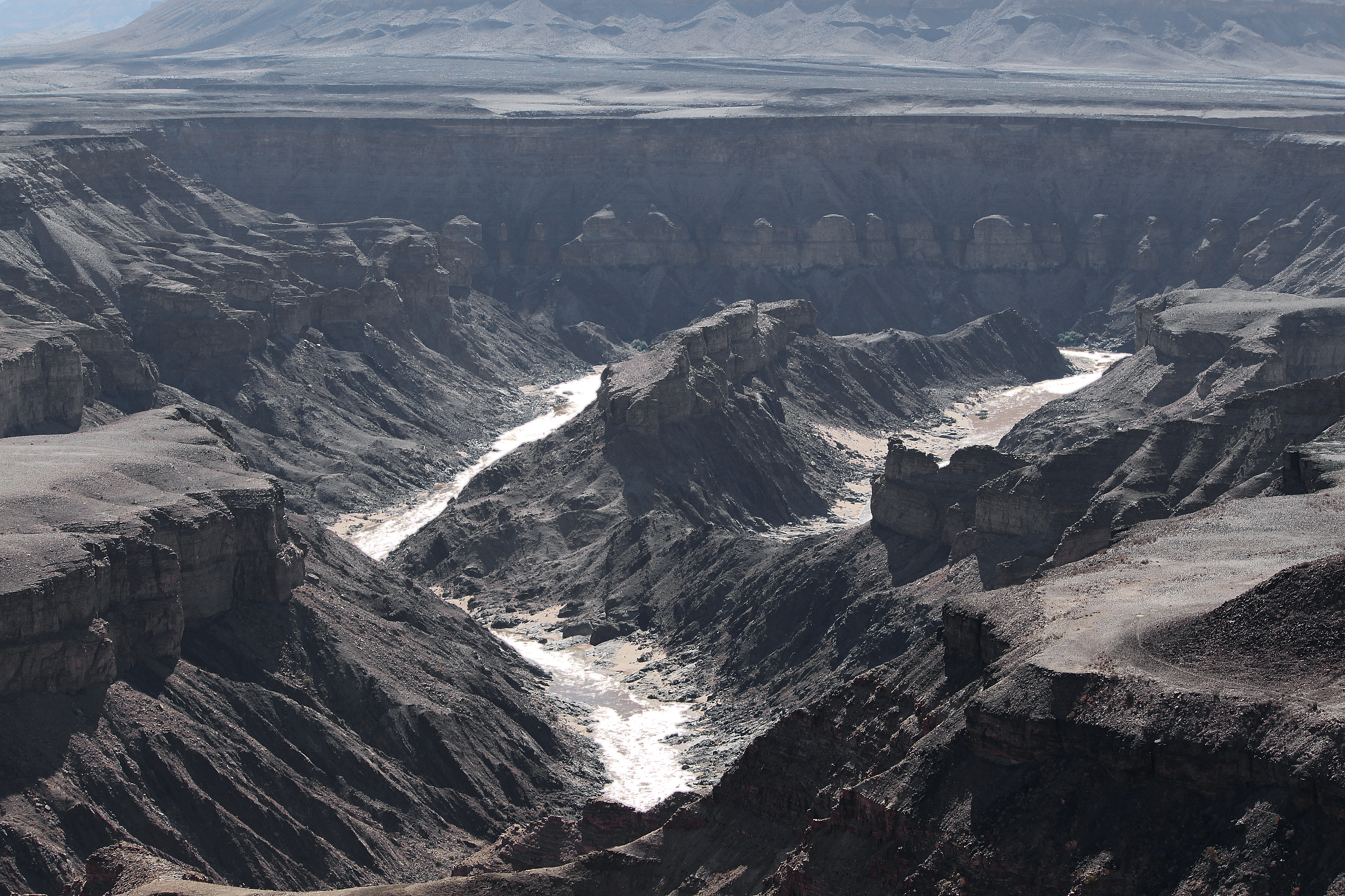
Fish River Canyon
📍 Karas Region · Southern NamibiaAfter the Grand Canyon, this is the biggest hole in the ground on earth — carved by the Fish River over 500 million years into a chasm 550m deep. The canyon rim at sunset, with shadow filling the gorge and the walls turning deep purple, is one of Namibia’s finest photographic moments. The 5-day hiking trail (87km, May–September only) follows the canyon floor past geothermal pools to Ai-Ais hot springs — one of Africa’s great wilderness walks.
🔴 Hike May–Sep only (flash flood risk other months) · Rim views year-round
Canyon Rim vs Hiking Trail
The canyon rim viewpoints require no permits and are accessible by any vehicle. The 87km hiking trail is a serious multi-day undertaking — permits from NWR (Namibia Wildlife Resorts), maximum group size 3 people, hiker self-sufficient. Medical certificate required. The Ai-Ais hot spring resort at the trail’s end has basic accommodation and the best hot thermal pools in southern Africa.

Quiver Tree Forest, Keetmanshoop
📍 Karas Region · Near Fish River CanyonA grove of 250 Aloidendron dichotomum (quiver trees) up to 400 years old — their silver trunks and bottle-brush canopies creating a Dr Seuss-like landscape at golden hour. At dusk, rock hyraxes emerge from the boulders and the sky turns the trees into black silhouettes against fire. One of southern Africa’s most distinctive landscapes.
Why Visit
The Quiver Tree Forest is 14km from Keetmanshoop and sits on a private farm — entry fee payable at the gate. The on-site campsite is exceptional for stargazing. The “Giant’s Playground” 2km away — balanced dolerite boulders the size of houses — combines perfectly with the quiver tree walk into a 3-hour circuit.
Ready to Explore Namibia?
Sossusvlei dunes at dawn, Etosha night waterholes, Skeleton Coast desert lions — or the full Namibia circuit across all regions. All quoted in KES. We handle logistics end to end.